


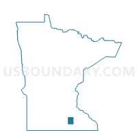
Meriden Twp. Voting District, Steele County, Minnesota
About
Outline

Summary
| Unique Area Identifier | 604557 |
| Name | Meriden Twp. Voting District |
| County | Steele County |
| State | Minnesota |
| Area (square miles) | 36.13 |
| Land Area (square miles) | 36.06 |
| Water Area (square miles) | 0.07 |
| % of Land Area | 99.80 |
| % of Water Area | 0.20 |
| Latitude of the Internal Point | 44.05882680 |
| Longtitude of the Internal Point | -93.33648750 |
Maps


Graphs
Select a template below for downloading or customizing gragh for Meriden Twp. Voting District, Steele County, Minnesota


Neighbors
Neighoring Voting District (by Name) Neighboring Voting District on the Map
- Blooming Grove Twp. Voting District, Waseca County, MN
- Clinton Falls Twp. Voting District, Steele County, MN
- Deerfield Twp. Voting District, Steele County, MN
- Lemond Twp. Voting District, Steele County, MN
- Owatonna Twp. Voting District, Steele County, MN
- Somerset Twp. Voting District, Steele County, MN
- Woodville Twp. Voting District, Waseca County, MN
Top 10 Neighboring County Subdivision (by Population) Neighboring County Subdivision on the Map
- Woodville township, Waseca County, MN (1,332)
- Somerset township, Steele County, MN (732)
- Meriden township, Steele County, MN (621)
- Owatonna township, Steele County, MN (609)
- Blooming Grove township, Waseca County, MN (525)
- Deerfield township, Steele County, MN (517)
- Lemond township, Steele County, MN (501)
- Clinton Falls township, Steele County, MN (351)
Top 10 Neighboring Unified School District (by Population) Neighboring Unified School District on the Map
Top 10 Neighboring State Legislative District Lower Chamber (by Population) Neighboring State Legislative District Lower Chamber on the Map
Top 10 Neighboring State Legislative District Upper Chamber (by Population) Neighboring State Legislative District Upper Chamber on the Map
Top 10 Neighboring 111th Congressional District (by Population) Neighboring 111th Congressional District on the Map
Top 10 Neighboring Census Tract (by Population) Neighboring Census Tract on the Map
- Census Tract 9601, Steele County, MN (4,706)
- Census Tract 9604, Steele County, MN (4,112)
- Census Tract 7903, Waseca County, MN (3,137)
- Census Tract 9605, Steele County, MN (2,830)